|
|
Patrick R. Galloway |

High quality, detailed topographic maps in digital format are now available for
the entire eastern
|
|
|
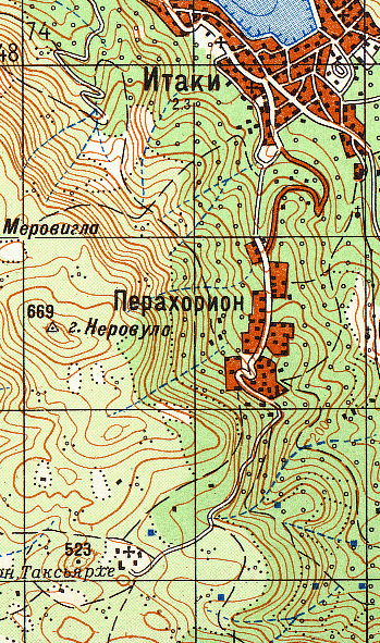
Ithaka village and Perakhorion village on Ithaka Island, |
As a service to those interested in detailed high
quality topographic maps, Patrick R. Galloway provides the following:
Albania 1:50,000
Greece 1:50,000
Turkey 1:100,000
Cyprus 1:200,000
Syria 1:100,000 (central desert 1:200,000)
Lebanon 1:100,000
Israel, Gaza Strip, West Bank, and Golan Heights 1:50,000
Jordan and West Bank 1:100,000
Iraq 1:100,000
Iraq 1:200,000
Kuwait 1:100,000
Iran 1:200,000
Egypt 1:200,000
Extraordinary accuracy
The Soviet topographic maps in the atlases are formerly classified Top Secret
Soviet Army General Staff maps. They are the best, and for some countries the
only, detailed topographic maps available. The maps show many features,
including airfields, fuel storage tanks, dams, ruins, caves, chapels, bridges,
roads, trails, and built-up areas. The
maps display over 750 different topographic features, just about anything you
can think of that would be of use to a Soviet field general. Each map also has a latitude scale, longitude
scale, distance scale, elevation contour lines, and spot elevation heights.
To see an image which compares a Soviet topographic map from the Greece
1:50,000 atlas with a NASA satellite photograph of Athens Hellenikon Airport and
nearby waterfront, click here (287 Kb
jpg). The overlay grid on the Soviet
map shows 1 km squares. Note the
accurately mapped airport layout, and the details of the waterfront, with all
its harbors, coves, and major buildings.
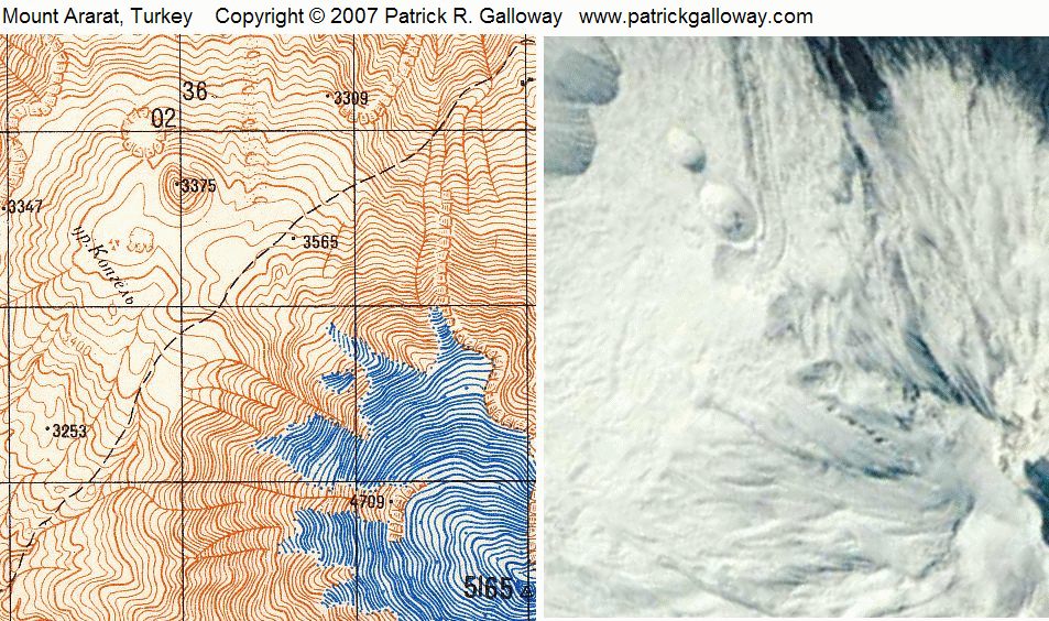
To see the area northwest of the summit of Mount Ararat in Turkey, click here (192 Kb jpg). The Soviet map is from the Turkey 1:100,000
atlas. The overlay grid shows 2 km
squares. The satellite photo is taken
from a somewhat oblique angle. Note the
cliff and circular formations to the northwest, the peak to the southeast, and
the various spot elevations. The map
shows a trail running from northeast to southwest.
To see Kharg Island, Iran, click here (88 Kb jpg). The Soviet map is from the Iran 1:200,000
atlas. The overlay grid shows 4 km
squares. The piers, fuel storage tanks,
western cliffs, airfield, the built-up area to the northeast, and the highest
elevation (87 meters) are clearly shown on the map. The 1:200,000 scale is the least detailed
scale of the atlases, but it still shows plenty of detail.
Software
The only software needed to view the atlases is a browser and a pdf
reader.
You will also need an SD card slot on your computer. No files are
written to your hard drive when you run the atlas off your SD card. You have the option of loading the atlas
files to your hard drive if you like.
Each Galloway Topographic Map Atlas Digital Version includes
- Key map. This shows the entire country.
- TPC maps. A TPC map always shows an area one degree latitude by one degree longitude. It is always at a scale of 1:500,000. The base maps for the TPC maps are United States and United Kingdom Tactical Pilotage Chart maps.
- Soviet topographic maps. The scales vary from 1:50,000 to 1:200,000 depending on country.
- Cyrillic to English transliteration table. Names on Soviet topographic maps are printed in the Cyrillic alphabet. A transliteration table which gives the sounds of the Cyrillic alphabet is included. You don't have to know anything about the Russian language to read the place names. You only need to know the sounds of the Cyrillic alphabet. Many of the letters have the same sound as in English. Names of important places and features are shown in English on the TPC maps. You can look at a Soviet map and its corresponding TPC map at the same time.
- U.S. Army Technical Manual TM 30-548 Soviet Topographic Map Symbols. This 104 page manual describes in English over 750 different Soviet topographic map symbols.
- Gazetteer. The Gazetteer shows place name, designation (town, river, mountain, ruin, etc.), province, latitude and longitude in degrees, minutes, and seconds.
Galloway
topographic map digital atlases work like paper atlases, but with many more
features than paper atlases. You use a
key map to take you to more detailed maps.
Instead of turning pages to get to the more detailed maps as in a book,
with a digital atlas you simply click on the area of interest. Furthermore, with a digital atlas you can
have multiple pages open at the same time, you can zoom in and out, and because
the whole atlas is on one SD card, it weighs practically nothing.
To use the
atlas, click on the area that you are interested in on
the Key map. This zooms you into a TPC
map. Then click on the area you are
interested in on the TPC map. This zooms
you into a Soviet topographic map. If
you do not know where a place is, you can use the Gazetteer. The samples explain how to use the gazetteer
with the maps.
Samples
These files are taken directly from the atlases. The Key map and TPC map are gif files about
one megabyte each, and the Soviet topographic maps are pdf files about two
megabytes each. It's best to have a fast
internet connection, or some patience.
Note that responses using the purchased disc in your disc drive will be
almost instantaneous. Click anywhere it
says "Click here" in red.
These are the features that have been activated in the sample
files. Click on the
"Introduction" button on the first screen you see if you want to
learn more about the maps and how to use them.
Each file will open into its own window.
Resize the Soviet maps, open windows, close windows, compare the Soviet
maps to the TPC maps.
The area around Khalkis, Greece from the Galloway
Topographic Map Atlas of Greece 1:50,000 Digital Version. Includes four of the 1,931 Soviet topographic
map pages found in the atlas.
The area around
Izmir, Turkey from the Galloway Topographic Map Atlas of Turkey
1:100,000 Digital Version. Includes
four of the 2,223 Soviet topographic map pages found in the atlas.
Image details
The TPC maps included in each atlas cover the entire country, all land and all
water. The Soviet maps cover land area
and water adjacent to land, as shown in the above samples. Because an image can be scanned in many
different of ways (depending on coloring, brightness, gamma, sharpening, and
other factors), each scanned image is unique.
Efforts have been made to present the images in the atlases in a manner
that is both informative and aesthetically interesting.
Image quality
Galloway Topographic Map Atlas
digital maps are high quality raster image files scanned from the actual paper
maps, not the poorer quality vector image or jpg files that are distributed by
some digital map vendors. Map scans from
other companies and institutions often have unwanted lines running through
them, the images are not in focus, or the map is misplaced on the scanner,
resulting in off-center and misaligned images.
Often the compression method blurs the details. All Galloway
Topographic Map Atlas images are high quality, high resolution
scans. Look at the image of the area
around Ithaka village on this page, or look at the samples.
Of special interest to archaeologists, and others
TPC maps are used as base maps for
most of the maps in the Barrington Atlas of the Greek and Roman World (2000),
ed., R.J.A. Talbert. As a consequence,
it is easy to find the locations of the Barrington Atlas ancient sites on both
the TPC maps and the associated detailed Soviet maps included in each Galloway
Topographic Map Atlas. Because the
Soviet topographic maps are zoomable to nearly any size, they are informative
when used together with a site plan, so
that the site may be viewed within a broader geographic context. Every
page in a Galloway Topographic Map Atlas has latitude and longitude scales, so
it is possible to precisely pinpoint any location.
Detailed descriptions
Click here.
Inquiries
For all inquiries and comments contact patrickrgalloway@gmail.com.
Copyright © Patrick R. Galloway
www.patrickrgalloway.com